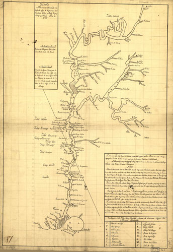
Costa de Venezuela / Orinoco Nuebamente Obserbado en bajante, afin de espresar Sus Raudales Yslas, y Bajos, Rios, y Caños que Rezibe....[Venezuela]. 1732. Pencil, pen-and-ink ms., 73 x 49 cm. Scale ca. 1:2,550,000. (Maggs purchase map collection; 124). 89-696372. This map of the Orinoco River valley contains extensive information about the Indian nations bordering the river, on Christian missions, on other settlements, on the extensive array of streams that flow into the Orinoco, and on navigational hazards and islands. Map contains a keyed index and a full historical note on the exploration of the river from 1682 to 1732. In the note is recorded information concerning the martyrdom of various religious. As the extensive note suggests, much of the information for this map was provided by various religious (for example Fray Silbestre Hidalgo, an Augustinian priest), military and government sources. This is a good example of the common practice in Spanish information gathering on the cultures, people, and geography of newly acquired Spanish lands in America. Map is oriented with southwest at top. This map is part of the G&M Division's collection from the Real Escuela de Navegación, Cadiz, Spain purchased from Maggs Brothers, London. |
 |
| fuente: Library of Congress |